


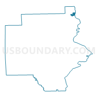
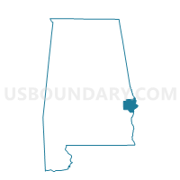
Russell County Courthouse, Russell County, Alabama
About
Outline

Summary
| Unique Area Identifier | 522844 |
| Name | Russell County Courthouse |
| County | Russell County |
| State | Alabama |
| Area (square miles) | 1.20 |
| Land Area (square miles) | 1.20 |
| Water Area (square miles) | 0.00 |
| % of Land Area | 99.91 |
| % of Water Area | 0.09 |
| Latitude of the Internal Point | 32.46874450 |
| Longtitude of the Internal Point | -85.00843860 |
Maps

Graphs
Select a template below for downloading or customizing gragh for Russell County Courthouse, Russell County, Alabama


Neighbors
Neighoring Voting District (by Name) Neighboring Voting District on the Map
- 21532 - FIRST AFRICAN Voting District, Muscogee County, GA
- 21533 - HANNAN Voting District, Muscogee County, GA
- National Guard Armory Voting District, Russell County, AL
- Roy Martin Center, Russell County, AL
- Spencer Recreation Center Voting District, Russell County, AL
Top 10 Neighboring County Subdivision (by Population) Neighboring County Subdivision on the Map
Top 10 Neighboring Place (by Population) Neighboring Place on the Map
Top 10 Neighboring Unified School District (by Population) Neighboring Unified School District on the Map
Top 10 Neighboring State Legislative District Lower Chamber (by Population) Neighboring State Legislative District Lower Chamber on the Map
- State House District 80, AL (54,900)
- State House District 132, GA (42,799)
- State House District 83, AL (41,039)
Top 10 Neighboring State Legislative District Upper Chamber (by Population) Neighboring State Legislative District Upper Chamber on the Map
- State Senate District 27, AL (139,166)
- State Senate District 15, GA (133,879)
- State Senate District 28, AL (131,368)
Top 10 Neighboring 111th Congressional District (by Population) Neighboring 111th Congressional District on the Map
Top 10 Neighboring Census Tract (by Population) Neighboring Census Tract on the Map
- Census Tract 306, Russell County, AL (6,672)
- Census Tract 307, Russell County, AL (3,793)
- Census Tract 303, Russell County, AL (3,548)
- Census Tract 16, Muscogee County, GA (2,749)
- Census Tract 302, Russell County, AL (2,091)
- Census Tract 111, Muscogee County, GA (1,992)